
48222
SmartCloudFarming
3D SoilMaps using Advanced Soil Analytics and Remote Sensing
Germany
Market: Farming, Other, Artificial Intelligence
Stage of the project: Idea or something is already done
Date of last change: 04.07.2020
Germany
Market: Farming, Other, Artificial Intelligence
Stage of the project: Idea or something is already done
Date of last change: 04.07.2020
Idea
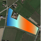
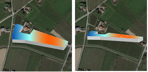
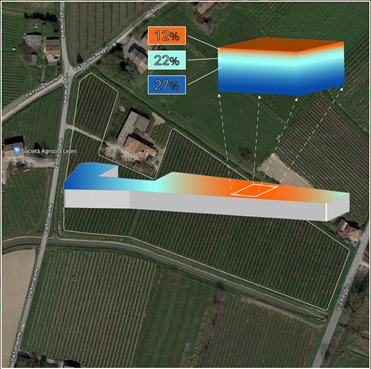
Only 3% of the earth's surface is arable with approx. 75 billion tonnes of fertile soil being lost each year due to land degradation. This directly affects over 3.2 billion people worldwide. SoilEye from SmartCloudFarming is an AI-driven precision farming solution that generates 3D digital soil maps for soil moisture, soil nutrients, and soil organic carbon. It can be integrated into software and in smart farming machinery and will help improve yields, save resources, and reduce agricultural emissions. While simultaneously improving soil fertility and biodiversity.
Current Status
Since its inception in 2019, SmartCloudFarming has made considerable progress in its technology and product development.
We have established collaborations with the University of Novi Sad/Serbia and Fraunhofer IOSB/Germany. Currently, we are exploring a partnership with CSIRO/Australia.
In the industry, we have a collaboration with GruppoCAP/Italy and have received expressions of interest from agricultural companies, fertiliser manufacturers in Europe, Brazil, UK.
We are currently developing our soil moisture maps prototype and testing the remote soil organic carbon algorithm. Later this year, we shall start field trials for our soil nutrient map development.
We are currently one of three European companies in the semi-finals of the global Terraton Challenge organised by Indigo Ag/USA and consider Indigo Ag to be a potential big customer for our remote soil organic carbon monitoring product.
By the end of this year, we shall be closing two pilot projects with prospective clients.
Market
We are targeting the following customers directly with 3D digital soil moisture, soil nutrition, soil organic carbon maps:
- Vertically integrated agri-businesses
- Large agricultural cooperatives
- Governmental agencies in EU, North America and later in Middle East and South America, Australia
- Fertiliser companies
Indirectly, we would also cater to industries wanting to offset their carbon production and require carbon offset validation mechanisms.
We are not targeting individual small-holding farmers due to sales/customer acquisition challenges.
Accoring to a 2016 study by Goldman Sachs, the precision farming market is slated to have a value of over $250 billion by 2050. In the areas of precision fertilisation and irrigation, the directly addressable market shall have a value of $100 billion with potential value adds adding another $315 billion. For field monitoring and data management, the directly addressable market shall have a value of $35 billion with potential value adds adding another $125 billion.
Problem or Opportunity
Problem:
The loss in agriculture due to poor soil health amounts to over $300 billion. This is due to poor soil management owing to a lack of useful and usable soil data that can be used together with precision farming tools. Current soil sensors have several drawbacks: 1. point data applicable to a tiny area on a vast field and not the whole field; 2. they are expensive; 3. not practical for use in all kinds of agricultural fields. Current 2D maps using remote sensing overcome problem 1 with soil sensors, but do not provide depth information. Farmers need much more the depth information than just the suface information. With SoilEye we are addressing this lack of useful and usable data and also plugging the technology gap, as the digital nature means they can be integrated into softwares and precision farming machinery.
Opportunity:
Accoring to a 2016 study by Goldman Sachs, the precision farming market is slated to have a value of over $250 billion by 2050. In the areas of precision fertilisation and irrigation, the directly addressable market shall have a value of $100 billion with potential value adds adding another $315 billion. For field monitoring and data management, the directly addressable market shall have a value of $35 billion with potential value adds adding another $125 billion.
Market Validation:
We have conducted extensive customer research in Germany, Italy, South Africa, Cyprus to validate the need we have described above. Besides, both agricultural companies and fertiliser manufacturers have contacted us regarding collaboration and pilot projects. A competition analysis has also revealed that one of the reasons precision agriculture startups are not making their mark is them not addressing key customer needs.
USP:
Only SoilEye can provide 3D digital soil maps that provide useful and reliable information for the user. Using millions of data points, SoilEye will allow remote soil management with a very high level of confidence at affordable prices. This will result in greater flexibility, lower costs and greater trust. With SoilEye we are sowing better economics in agriculture.
Solution (product or service)
SoilEye is a software application that would be offered as a stand-alone version and a REST API.
The application would be a web-app (initially) that woud allow the user to mark their fields and display soil moisture, nutrients and organic carbon content in 3D form and also as 2D against a time scale. Based on the output, soil management recommendations would be offered to the user as also product recommendations (mid-term). The user would also be able to combine this with weather data to automate actions such as irrigation.
The REST API would allow integration into existing software and precision farming machinery. This would enable event-driven actions such as farm automation, monitoring workflow automation, remote monitoring on a dashboard, precision fertilisation.
At a later stage we shall make suitable data available to fertiliser companies for the creation of customised fertiliser mixes.
Competitors
Our competitors are both soil sensor companies and remote sensing companies active in the agricultural space. Some of our direct and indirect competitors are:
Sensor Companies: Terralytic, Stenon, SoilCares, SoilOptix
Remote Sensing Companies: Gamaya, Hummingbird Technologies, Resson, VanderSat, Vultus, etc.
Existing alternatives are 2D soil maps and recommendations based on remote sensing and soil sensors that need to be planted in fields to receive soil data via a phone network and shown on a dashboard.
Advantages or differentiators
Only SoilEye can provide 3D digital soil maps that provide useful and reliable information for the user. Using millions of data points, SoilEye will allow remote soil management with a very high level of confidence at affordable prices. This will results in greater flexibility, lower costs and greater trust.
The main differentiator is our 3D soil map that no one else produces. With it and our strong customer focus, we are positioning ourselves as a service oriented company and not just a technology startup.
Our main advantage is the 20+ million data points that we have and this is continuously growing as we enter into new partnerships.
Finance
Revenue generation by making soil information available in a digital format and as 3D maps, that can be integrated into existing software and machinery. The can be used to deliver value-added services.
Revenue streams:
1. 3D soil maps, analyses, soil management recommendations
1a. Automation services (e.g. irrigation) based on events in 1.
2. Remote soil organic carbon monitoring
2a. Carbon offset verification
3. Farmland evaluation based on soil fertility
4. Farm2Fertiliser Matching: soil data to fertiliser companies for customised fertilisers
KPIs:
API calls, EBIT, EBIT Margin, Return on sales, Cashflow as % total revenue, Sales by product
Modelled prices:
Soil organic carbon detection: 15 EURO - 2000 EURO/hectare or 0.20 EURO/API call depending on customer segment
Soil moisture maps: 5 EURO/hectare or 0.20 EURO/API call
Soil nutrient maps: 4 EURO - 10 EURO/hectare or 0.20 EURO/API call depending on customer segment
Soil data points: 1000 EURO/hectare dataset
Sales expectations for next 5 years:
We woud be generating our first revenue in 2021. This would be a small one from paid pilot projects. 2022 onwards we shall be earning from our products and services. Projected revenues in EURO are 3.08 million, 25.8 million, 38.9 million and 94.4 million.
Business model
Business model: Information-as-a-Service and derivatives based on that.
Our Go-2-Market strategy is as follows:
Stage 1: Paid pilot projects; Channels: Direct Acquisition | Network
Stage 2: Partnerships and 3. party integrations; Channels: Direct Acquisition | Online | Network | Tender participation
Stage 3: Direct partnerships with OEMs and fertiliser companies; Channels: Direct Acquisition | Network
KPIs:
CAC, Customer churn/retention, Sales by customer, Profit by customer, Segment growth
Money will be spent on
The investment will be used for:
- technology development
- product development, testing, readiness
- field tests
- service design
- data acquisition
- cloud infrastructure
- customer acquisition & sales
- business development
- service team creation
- team training & qualification
- travel and participation in seminars, etc.
- product deployment
- hardware and IT
- patent filings
Offer for investor
As we are raising our seed investment round, our preferred option is a SAFE agreement or convertible equity participation. Failing this we shall go for the next option of equity participation where we shall offer 15% equity for an investment of $2.5 million.
Team or Management
Risks
The risk that we could encounter is access to data being blocked in certain countries. This could mean we stop operating there or we circumvent it by establishing a subsidiary in that country. However, this has its limits as we cannot establish subsidiaries in every country.
On the customer front, we have ascertained a very high readiness to adopt services such as ours. Therefore, we do not foresee acceptance or adoption as an issue.
On the customer front, we have ascertained a very high readiness to adopt services such as ours. Therefore, we do not foresee acceptance or adoption as an issue.
Incubation/Acceleration programs accomplishment
EXIST/Germany, Copernicus Accelerator, Copernicus Incubator
Won the competition and other awards
DBU Green Challenge, Berlin Deep-Tech Award 2019, Fraunhofer TechBridge Venture Winner 2019, IE Venture Days Berlin 2020 Winner, PARSEC Phase 1 Winner
Photos


Presentation
Sign in/Sign up